Related Resources: calculators
GPS Coordinate Conversion Calculator
GPS Coordinate Conversion Calculator
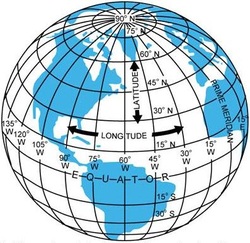
UTM to Latitude and Longitude Converter CalculatorThe UTM system divides the Earth into 60 zones, each 6° of longitude in width. Zone 1 covers longitude 180° to 174° W; zone numbering increases eastward to zone 60, which covers longitude 174°E to 180°. The polar regions south of 80°S and north of 84°N are excluded.
Each of the 60 zones uses a transverse Mercator projection that can map a region of large north-south extent with low distortion. By using narrow zones of 6° of longitude (up to 668 km) in width, and reducing the scale factor along the central meridian to 0.9996 (a reduction of 1:2500), the amount of distortion is held below 1 part in 1,000 inside each zone. Distortion of scale increases to 1.0010 at the zone boundaries along the equator.
In each zone the scale factor of the central meridian reduces the diameter of the transverse cylinder to produce a secant projection with two standard lines, or lines of true scale, about 180 km on each side of, and about parallel to, the central meridian (Arc cos 0.9996 = 1.62° at the Equator). The scale is less than 1 inside the standard lines and greater than 1 outside them, but the overall distortion is minimized.
Check out the following
- Vector Calculus Cartesian Coordinates
- Area By Coordinate Method
- Mohrs Circle for Plane Stress
- 2D CAD Static's Modeler and Loads Calculator
- Simple 2D Cad Sketcher
- Simplified Statics 2D modeler and structural reaction loads calculator
- Spur Gear and Gear Assemble Builder
- Electronic Circuit Modeler, Builder and Simulator
- AISC Steel structural Shapes Property Viewer
- Fluid Dynamic Simulator and Stress Reliever
- Mechanism Creator and Editor Online Application
- Truss Calculator Builder And Solver Application
- Stress-Strain Calculator and Plotted Curve Approximation using Ramberg-Osgood Equation
- Visual Math Editor LaTeX, MathML, AsciiMath codes , mhchem and html - Multi Language Support
Link to this Webpage:
© Copyright 2000 -
2024, by Engineers Edge, LLC
www.engineersedge.com
All rights reserved
Disclaimer |
Feedback
Advertising
| Contact